Governance analysis framework
Introduction
According to the United Nations Development Programme (UNDP), governance is defined as “the rules of the political system to solve conflicts between actors and adopt decisions (legality)” and also as the “proper functioning of institutions and their acceptance by the public (legitimacy)”. Regarding territorial governance, the Council of Europe of Ministers Responsible for Spatial Planning (CEMAT) defines it as “a global concept which characterizes the way spatially-relevant policies, considered together, are applied” or as “the result of multi-level and cross-sectorial relationships in the field of public policies”, also referring to “horizontal and vertical cooperation in the shaping and implementation of these policies”. According to Van Tatenhove (2011), marine governance is defined as: “the sharing of policy making competencies in a system of negotiation between nested governmental institutions at several levels (international, supra national, sub-national) on the one hand, and state actors, market parties, and civil society organizations of different maritime activities on the other in order to govern activities at sea and their consequences”.
Construction of a governance framework: the PORTODIMARE example
On the base of the above definitions, the need of integrating a governance analysis in the ICZM/MSP framework addressed within the PORTODIMARE project’s activities was seen as fundamental. In fact, during the collection of data and information, it was asked to the partners to provide data and information on the governance framework of their coastal and marine space along with all the relevant spatial data and information that were made available and collected during activity 1.2 – Geoportal data and information requirements – to feed the necessary knowledge related with the PORTODIMARE area of study. The scope of this request was to structure a concrete governance framework that would: help identify and find appropriate mechanisms for dealing with conflicts and synergies between sectors; facilitate sectorial involvement; clarify the roles and responsibilities of relevant institutions and organisations; support the adoption of an integrated approach in coastal and maritime spatial planning initiatives; build a complete and coherent knowledge framework incorporating all the relevant information needed to support the on-going and future MSP initiatives in the project area. Moreover, the acquisition of governance information ensures the sharing of all the relevant knowledge among the countries bordering the Adriatic-Ionian Region (AIR) to boost the transboundary approach and cross-border initiatives that should be mandatory for the nature of MSP in itself. Furthermore, it was seen as a useful way for developing and testing a method for analysing and evaluating governance of on-going spatial planning initiatives.The work was structured through an Excel Table to compile, and a Word Document (instructions to facilitate the compilation) that were sent to all the partners involved in PORTODIMARE. These documents were meant to facilitate the collection of policy, planning and governance data. The knowledge collected was used to create a detailed picture of the governance schemes and instruments insisting in the various project’s areas. This work facilitated the overall goal of collection of information/data for the Geoportal and feed the construction of the Maritime Use Conflicts (MUC) module, as well as of the various connected modules with special regard to the Cumulative Effects Assessment (CEA) one. Moreover, the compilation of the document enabled the geographical collection of the scale of competence and domain areas of the planning instruments.
Data model
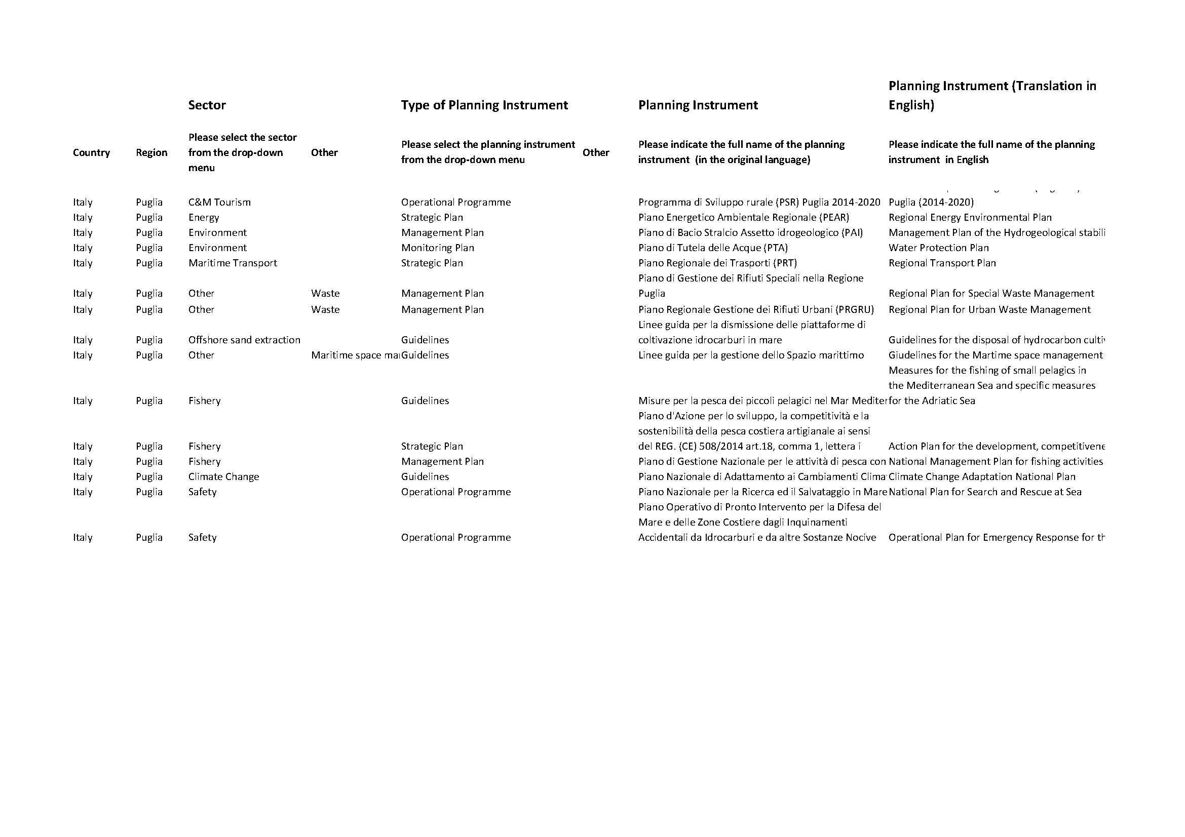
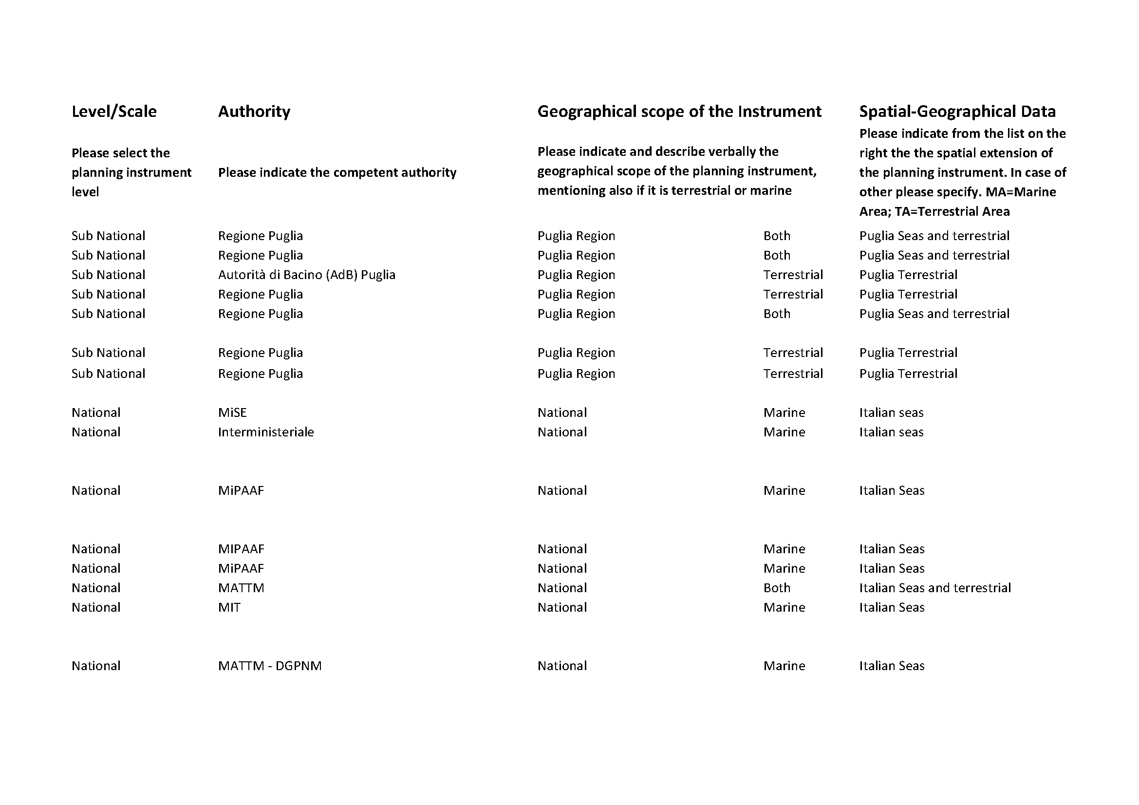
The Excel Table was subdivided in different categories in order to guide the collection of all the meaningful information on policy and governance instruments in the reference area. The different categories were:
Country
Region
Sector (selected from a drop-down menu which included all the relevant MSP sectors)
Type of planning instrument (selected from a drop-down menu with the following categories: guidelines, strategic plan, management plan, operational programme, monitoring plan)
Name of the planning instrument (in the original language)
Name of the planning instrument (in English)
Level/Scale of application (international, national, subnational, local)
Authority (competent authority in charge of the planning instrument)
Geographical scope of the instrument (indicating the level and scope of the planning instrument, mentioning also if it is terrestrial, marine or both)
Spatial-Geographical Data (Spatial extension of the planning instrument from a list of domain areas provided)
Shapefile (in case the spatial extension is not in the domain areas already collected, provide a shapefile of the areas of competence)
Link (web link to the planning instrument and/or data)

Fig. 19 Snapshots of the Excel Table provided and compiled for the collection of all the relevant governance information (Part 1).

Fig. 20 Snapshots of the Excel Table provided and compiled for the collection of all the relevant governance information (Part 2).

Fig. 21 Snapshots of the Excel Table provided and compiled for the collection of all the relevant governance information (Part 3).
MSP considerations
The governance analysis framework provides a structured approach for analysing governance aspects in the region, by ‘deconstructing’ the governance framework into different incentive categories and sectors.
Governance considerations are useful for involving or at least identifying all competent authorities and stakeholders in maritime spatial planning procedures, in a meaningful way. The governance analysis and information are useful to support the understanding of the origin and meaning of the main identified conflicts between uses and between uses and the environment, and, eventually, to orient management and planning measures after the definition of the responsible/competent authority in charge, and of the actions/measures that are already in place.
References
Council of Europe of Ministers Responsible for Spatial Planning (CEMAT)
INTERREG Adriatic-Ionian Programme – ADRION PORTODIMARE geoPortal of Tools &Data for sustainable Management of coAstal and maRine Environment. https://portodimare.adrioninterreg.eu/
United Nations Development Programme (UNDP)
Van Tatenhove, J. (2011). Integrated marine governance: questions of legitimacy. Mast, 10(1), 87-113.